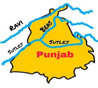
The Geographical Structure of Punjab
The meaning of Punjab is the Land of five rivers - Sutlej, Ravi, Beas, Chenab, and Jhelum but after the partition, there are only three rivers in Punjab - Sutlej, Ravi, and Beas. Punjab lies in the northwestern corner of the country. Punjab shares its border with the Indian union territories of Jammu & Kashmir to the north, Chandigarh to the east, Himachal Pradesh to the north and northeast, Haryana to the south and southeast, and Rajasthan to the southwest. It touches an international border by Punjab, a province of Pakistan in the west. The city of Chandigarh is the administrative capital of Punjab. Agriculture is the main occupation of the people, and it is the backbone of the state economy. The state of Punjab has as many as 23 districts.
- Punjab is
spread over an area of 50,363 square kilometers and It's ranked 16th by population and
19th by area.
- Punjab
shares its borders with Himachal Pradesh, Haryana, Rajasthan, Chandigarh,
& Jammu Kashmir.
- Chandigarh
a union territory is the capital of Punjab.
- As per the
2011 census, Punjab has a population of approximately 27 million people.
- The
largest city in Punjab is Ludhiana.
- Mr.
Bhagwant Mann from AAP is the chief minister of Punjab.
- Punjab is
famous for Golden Temple, Jallianwala Bagh, and Wagah Border.
- The
official language of Punjab is Punjabi.
- Punjab is
famous for Makke di roti and Sarso da sag, Lassi, Chhole Bhature, Pinni,
and Tandoori Chicken.


Comments
Post a Comment